
Rauna : German Brief
This is a part of the Battle of Cēsis. On 21 June three Baltic Landeswehr columns attacked to the north and east the town. The most northerly attack was repulsed, but the two other columns broke through the Estonian lines to the east of Cesis town, dispersing the Latvian 2nd Cēsis Regiment. These columns then peeled out, with the more northerly driving the main body of fleeing Latvians northwards, and the more southerly bearing mostly eastwards. This left the Estonian 3rd Regiment isolated at the southern end of the Estonian line and it had to fall back on Rauna during the evening.
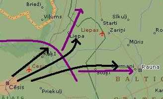
basic sketch, off a modern map
The game represents the next day, as the south-most column of Baltic Landeswehr pressed its attack further, trying to drive the Estonians out of Rauna and away from the rest of the Estonian army.
Freikorps brief
You are Major Böckelmann, commanding a column of the Baltic Landeswehr. Actually almost all of your men are Reich Germans attached to the Landeswehr for political reasons.
Your attack in this sector was successful yesterday, but mainly because you threatened the enemy with envelopment otherwise. They fell back to a line Muris–Smurgis–Baizkalna Estate–Rauna River–Mierens.
Today it is important for you to drive the Estonians from Rauna to the east. It is not necessary to destroy them, merely forcing them to retire will achieve your desired result of separating them from the rest of their army, which to your north.
Your attack will commence at 6:30, in order to give your men some rest.
Your men
2-i-C
Baden Assault Battalion:
1st Infantry Company – 4 bases
2nd Infantry Company – 4 bases
3rd Infantry Company – 4 bases
MG Company – 3 bases
Signals Platoon
Battery – 2 heavy howitzer bases
Michael Detachment:
1st Infantry Company – 3 bases
2nd Infantry Company – 3 bases
3rd Infantry Company – 3 bases
MG Platoon – 1 base
Squadron – 4 bases
Mortar Platoon – 2 bases
Battery – 2 field gun bases
2 Iron Division armoured cars – 1 model
The Baden and Michael detachments are independent and not used to working together. Their units and commanders must remain separate.
The infantry companies are well trained, well equipped and motivated by yesterdays success. Your cavalry is really only mounted infantry, but well trained for scouting.
The signals platoon has a couple of light signaling devices and some mobile telephones with wire. They have rigged up quite adequate telephone communication with your HQ in Cesis town. You also have three radio sets: these are WWI quality, so are fragile and unreliable and take a while to tune back in once they have moved but, provided you avoid low ground, have sufficient range for the whole area. There are a handful of flares to spread around.
Your artillery batteries have 40 minutes supply. You can expect a resupply to arrive from the rear during the morning.
Your mortars have 30 minutes supply, most of which is carried in a couple of small horse-drawn carts (although you may designate some infantry to carry it through difficult terrain on their behalf, if you wish).
The armoured cars are theoretically under your command, but notoriously independent minded. They are reluctant to leave the roads, since they have no repair facilities, and the two cars will stick together at all times. They come with a dedicated motorcycle messenger, who you can use to communicate with them.
From time to time you may have aerial support from the 433rd Reconnaissance Flight. The terrain makes it very difficult for them to spot troops, let alone attempt to distinguish between the sides, and impossible for them to land. Your signals platoon have some equipment for helping the planes recognise your HQ and spot enemy artillery. You may attempt to relay messages to the airfield via the Cesis HQ.
The enemy
You face elements of the Estonian 3rd Regiment (about 1,000 bayonets), which offered stiff resistance yesterday. They do not seem to have much artillery or many MGs.
There are also some remnants of the Latvian regiment, largely destroyed in yesterdays fighting.
Terrain
You have been in the area some time and your map is accurate. You may question locals about any particular items of interest.
The area is relatively hilly, for Latvia. That and the fir forest cover (basically assumed to be 30m high) prevents most long range viewing. The forests themselves do not have much undercover and are relatively easy going, except when boggy, in which case they become almost impassable. Some of the river banks have deciduous trees and are scrubbier.
The Rauna River is frequently cliff-lined and fairly swift, but is slowly fordable by (determined) foot before it merges with the Cimzas River. The cliffs are more like steep banks than vertical rock faces but the softness of the ground makes them very hard to scale.
The bridges on the main roads are fairly sturdy wood except: the Pskov highway is stone or covered culvert; and the crossing immediately west of Rauna is a ford with cuttings on each side into the banks to make access easier.
The area is scattered with small farms, each only a few buildings clumped together, usually fenced. There are no other fences or hedges, but some ditches, especially along the roads or near boggy areas. There are occasional rye crops provide good cover if infantry take care to move through them slowly.
Assume each farm will take basically a platoon (i.e. base) for the night. Troops assembling in the morning will not be able to do this without being seen (if the enemy has a line of sight naturally).
Miscellaneous
A base represents approximately 30 fighting men, 4 MGs or 2 guns.
Your infantry use the standard Iron Division values, the MGs the standard values (not MGSS Abt).
The Latvians did not clump their farms into tight villages. Therefore issuing orders with reference to a named place, while perfectly acceptable, is not precise. It is quite possible for troops to march through a "village" and not know they have done so, because on the ground it just looks like another set of indistinguishable farms scattered around. Therefore the marker for most named places is the road intersections, not the buildings.
The areas of trees are bright green for fir and a slightly duller green for the scrubby deciduous forests along the waterways and the park at Baizkalna manor. The yellow areas on the other forests indicate swampy areas.